Flood Watch
Update - December 13, 2025 - 1:30 pm
City staff have been out inspecting conditions in our trails and parks and have determined the area between Vedder Park and Peach Road of the Rotary Trail to be safe at this time. That area of trail, as well as the Vedder and Peach Road parking lots have been reopened, but the Lickman Road parking lot and area remain closed at this time (please see the map below). Please continue to use caution near the river, as flow and velocity remain elevated. Crews will continue to assess conditions for safety and adjust closures accordingly.
With the temporary reprieve from the rain today, we understand people want to get out and enjoy our beautiful parks and trails, but we ask that residents still use caution and respect areas with posted signage and closures.
Please continue to check chilliwack.com/floodwatch for updates and DriveBC for updates on highway closures. 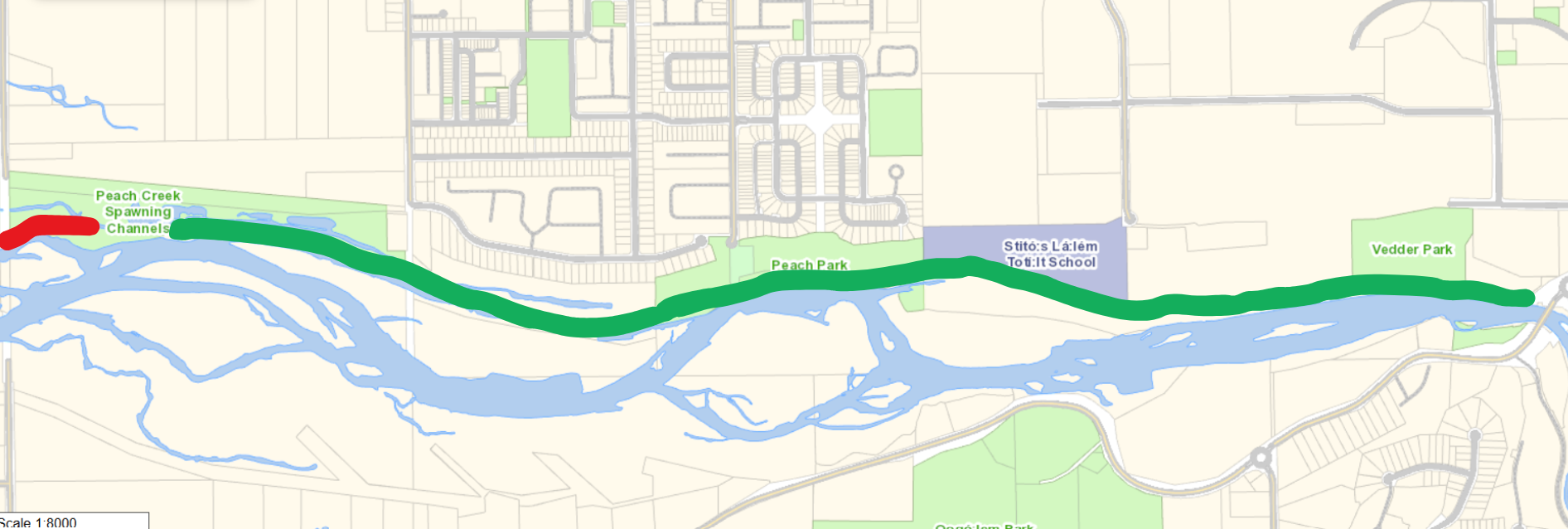
Update - December 13, 2025 - 10:30 am
Environment and Climate Change Canada is forecasting a “prolonged wet pattern” from Sunday, December 14, to Tuesday, December 16, including snow melt at higher elevations, which will run off into local rivers. With this weather, there may be some localized flooding and an increased risk of debris slides due to the ground already being oversaturated. We also expect a rise in the Vedder River with the upcoming rain, but river forecasts show the flows in the coming days are expected to be lower than what occurred on Wednesday night.
The BC River Forecast Centre is the provincial authority that monitors and forecasts river levels, then updates and issues flood watches/warnings for municipalities as required. We are sharing information from Environment and Climate Change Canada and the BC River Forecast Centre in order to ensure residents are kept up to date on developments that may impact our community.
City staff will continue to monitor river levels, and crews will continue to respond to weather-related events throughout the weekend. Staff remain in close communication with the City of Abbotsford and the Fraser Valley Regional District about conditions that may impact Chilliwack.
Continue checking chilliwack.com/floodwatch for updates.
For updates on highway closures, please check DriveBC and avoid travel to the Fraser Valley unless necessary.
Update - December 12, 2025 - 12:00 pm
On December 11, at 8:30 pm, we issued an evacuation ALERT for eight properties on Patterson Road due to localized flooding. An evacuation order remains in place for two properties on Marble Hill Road due to a debris slide.
There are some debris slides and localized flooding within Chilliwack municipal boundaries. Thank you to crews who have been working around the clock to address these challenges.
The BC River Forecast Centre reported this morning that the Nooksack River in Washington State is no longer overflowing into the Sumas River, and they expect a gradual receding of water over the next several days. As more rain is in the forecast, staff will continue to monitor the situation and provide updates within our municipal boundaries as new information is available.
Highway 1 remains closed between Highway 11 and No. 3 Road. Essential travel only is advised. Please be sure to visit DriveBC for up-to-date information on road closures.
The Fraser Valley Express (Route 66) is not operating between Chilliwack and Abbotsford due to the highway closure. Expect delays on Transit Routes 71 (Agassiz-Harrison) and 72 (Hope). Please visit BC Transit for updates.
Please check the City of Abbotsford and the Fraser Valley Regional District’s websites and social media for information within their boundaries.
Remember to check for updates by visiting chilliwack.com/floodwatch.
You can also sign up to receive emergency alerts at chilliwack.com/alertable.
Update - December 11, 2025 - 8:30 pm
The City of Chilliwack has issued an evacuation alert for eight properties on Patterson Road in response to flooding caused by heavy rain in the area. The notice has been hand-delivered to the eight properties shown on the map below.
Residents who receive evacuation alerts are advised to prepare for a potential evacuation order, as conditions can change. This includes:
- Organizing an emergency supply kit with necessary prescription medications, personal toiletries, a change of clothing, insurance papers and other important documents.
- Locating all family members and designating a meeting place if an evacuation is ordered while separated.
- Preparing to move any disabled persons and/or children.
- Moving pets to a safe area.
- Arranging accommodation for your family if possible. In the event of an evacuation, Reception Centres may be opened if required.
- Monitoring news sources for information on evacuation orders.
The City of Chilliwack will continue to provide updates for areas within our municipal boundaries as new information is available.
You can view the entire Press Release here.

Update - December 11, 2025 – 4:00 pm
The BC River Forecast Centre has ended the Flood Warning for the Lower Fraser tributaries, including the Chilliwack River. In addition, Environment and Climate Change Canada (ECCC) has ended rainfall warnings for our region. ECCC has reported that observed rainfall totals since Tuesday have ranged from 85 to 145 mm.
The BC River Forecast Centre is maintaining a Flood Warning for the Sumas River, including spillover from the Nooksack River. They reported that the Nooksack River reached peak levels this morning and that spill of the Nooksack River into the Sumas River drainage is expected to continue throughout the day, easing this evening. Flows on the Sumas River are expected to recede on Friday morning.
The City of Chilliwack will continue to provide updates for areas within our municipal boundaries as new information is available.
Remember to check for updates by visiting chilliwack.com/floodwatch. You can also sign up to receive emergency alerts at chilliwack.com/alertable.
Please check DriveBC to stay up to date on road closures and alerts.
Update - December 11, 2025 – 2:00 pm
The City of Chilliwack has declared a state of local emergency and issued an evacuation order for two properties on Marble Hill Road in response to a debris slide caused by heavy rain in the area. The two impacted properties have received hand-delivered notices from City staff.
The City of Chilliwack will continue to provide updates for areas within our municipal boundaries as new information is available.
Remember to check for updates by visiting chilliwack.com/floodwatch. You can also sign up to receive emergency alerts at chilliwack.com/alertable.
You can view the entire Press Release here.
Update - December 11, 2025 – 9:00 am
At this time, no evacuation alerts or orders have been issued within the City of Chilliwack municipal boundaries. Staff have been monitoring conditions all night and have remained in close communication with City of Abbotsford and Fraser Valley Regional District staff, who have had evacuations in their regions. Some news outlets have been reporting on the Chilliwack River Valley, but these properties are within the Fraser Valley Regional District and are outside of the City of Chilliwack municipal boundaries.
Local updates:
- There is some localized flooding in Greendale, between Hopedale West and Spurline Road, and on Sumas Prairie Road in downtown Greendale, due to heavy rainfall.
- High ditches have caused localized flooding in East Chilliwack along McGuire Road, Upper Prairie Road, and Patterson Road.
- Crews are working on a blocked culvert on Chilliwack Mountain Road.
- Equipment has been deployed to address a small debris flow on Marble Hill Creek.
The City of Chilliwack will continue to provide updates for areas within our municipal boundaries as new information is available.
Remember to check for updates by visiting chilliwack.com/floodwatch. You can also sign up to receive emergency alerts at chilliwack.com/alertable.
Please check DriveBC to stay up to date on road closures/alerts.
Photos taken December 10, 2025:

Standby Excavator at Town Creek Sediment Trap on Bowman Road on Majuba Hill

Vedder River at Lickman Road

Vedder River looking upstream from Lickman Road

Vedder River Rotary Trail, North Side at Lickman Road
Update - December 10, 2025 – 6:00 pm
City staff are aware of the Evacuation Alert for properties in the Sumas Prairie West and Clayburn Village regions of Abbotsford, and will remain in close communication with City of Abbotsford staff throughout this event.
The City of Chilliwack will communicate any evacuation alerts and orders that occur within our municipal boundaries directly to the affected properties, as well as through social media, our website and through the Alertable App.
For alerts and orders within the Fraser Valley Regional District, please visit https://www.fvrd.ca/, or within the City of Abbotsford, please visit https://www.abbotsford.ca/.
December 10, 2025 - 3:50 pm
Sandbags are available at Heritage Park (44140 Luckakuck Way) by the sani-dump station, and at the Yarrow Sports Field (3635 Savoy Road). Please bring a shovel with you!
December 10, 2025
On December 10, 2025, the BC River Forecast Centre upgraded to a Flood Warning for our region. This includes the Sumas River and Lower Fraser tributaries. To read the full alert from the River Forecast Centre: https://bcrfc.env.gov.bc.ca/warnings/advisories/FWN_2025_12_10_1000_SC_upg.pdf.
City staff are following Phase 2 - Rising Water of our Flood Response Plan for the Vedder River, which includes hourly dike patrols and the closure of all trails and parking lots along the Vedder River. We are asking people to stay away from these areas for now.
River conditions are elevated from rainfall earlier this week and are now rising further in response to the series of atmospheric rivers that have been impacting the United States Pacific Northwest and the south and central coasts of BC through this week. The most recent storm started overnight Tuesday/Wednesday and is expected to continue through the day on Wednesday, indicating total precipitation amounts today of 80 to 110 mm in the Lower Mainland.
Heavy rain and high streamflow bring increased risk for swift water hazards, flooding and landslides. Stay away from rivers, creeks and culverts and never drive through flooded roadways.
Review personal flood emergency plans and be prepared to implement if needed.
- Localized flooding can be reported through the City of Chilliwack app, or by calling our Operations Department at 604.793.2810.
- To sign up to receive emergency alerts, please visit chilliwack.com/alertable
- The River Forecast Centre continues to monitor the conditions and will provide updates as conditions warrant.
For tips on how to prepare for emergencies, please visit our Emergency Preparedness webpage or visit PreparedBC.
City staff are actively monitoring local conditions, as well as any new information from the BC River Forecast Centre, and will respond as needed.
Stay safe, stay aware, and check on neighbours who may need assistance.
-
Don't drive through flooded roadways.
-
Stay away from rivers, creeks and culverts.
Flood Information Phone Line - 604-793-2757
December 9, 2025:
On December 9, 2025, the BC River Forecast Centre issued a Flood Watch for our region. City staff will continue to monitor conditions and forecasts.
- Localized flooding on the roads is likely and some roads may become impassable.
- Visibility may be suddenly reduced at times.
- Don't drive through flooded roadways.
- Stay away from rivers, creeks and culverts.
- Expect trail closures.
- Please ensure storm drains near your house are clear of any debris.
Please visit the Vedder River Flood Protection Page for information.
To sign up to receive emergency alerts, please visit chilliwack.com/alertable.
For tips on how to prepare for emergencies, please visit our Emergency Preparedness webpage.
Visit our webpage for more tips about how to stay safe around rising water.
Report Localized Flooding
Report localized flooding through the City of Chilliwack app, or by calling our Operations Department at 604.793.2810.
| Attachments | |||
| Description | Date | File Size | |
 |
December 13 - Trail Map | 2025-12-13 | 413KB |